| Eco Companion Australasia |
| Help |
| help | about | home | feedback | member services | browse | search | new | glossary | join |
Using this document management facility you can describe your collections of geospatial data. You will be guided through the procedure of documenting a dataset using fill-out forms. Dataset descriptions are explained in the document "About dataset descriptions".
Whenever you choose to update your dataset description, your existing details will be presented in a set of HTML forms. Simple interfaces (with pre-defined option lists and error checking) allow you to complete each section of the document at your own pace. The application will ensure that all required fields are present and legitimate.
When you have completed all of the mandatory sections (achieved all stars or green lights) then you will be presented the option to have your dataset description processed by ANZMP. This will validate your dataset description, generate presentation documents, and give you the option to publish. The procedure is explained in the help document "Managing your dataset descriptions with ANZMP".
See the ANZLIC guidelines "Core Metadata Elements for Land and Geographic Directories in Australia and New Zealand" for explanation of the allowed content for each element. "GI Connections" has a useful online version of the ANZLIC Guidelines (Version 1) document.
To give you better control over presentation, many fields can accept either plain text (presented as a single paragraph) or a limited set of HTML elements. The two tables below explain the "Inline text elements" and "Block text elements" that can be used.
Inline text elements Description tt teletype (fixed width font) i italic b bold big big font small small font em emphasis (usually italic) a anchor, hypertext link to Internet resource br forced line break sub subscript sup superscript
Block text elements Description p paragraph pre pre-formatted (fixed width font) ul unordered list ol ordered list li list item dl definition list dt definition title dd definition data
This facility then gives you some control over the presentation of those fields. Use it only when needed for emphasis. Here are some examples, adding fragments of HTML to the <abstract> ...
Example 1: using paragraph, bold, hyperlink, and list elements
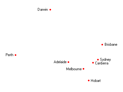
<p>
The datafile <b>capital.csv</b> has the following format ...
</p>
<ul>
  <li>city_name</li>
  <li>longitude</li>
  <li>latitude</li>
</ul>
<p>
This crude example map
<a href="http://www.indexgeo.com.au/data/capital/capital.gif">capital.gif</a>
was generated from this datafile.
</p>
... will be presented as a paragraph, followed by a list, followed by a paragraph with a hypertext link ...
The datafile capital.csv has the following format ...
- city_name
- longitude
- latitude
This crude example map capital.gif was generated from this datafile.
Example 2: concise lists or line-breaks
A concise list using the <dl> definition list ...
<dl>
 <dt>Title one</dt>
 <dt>Title two</dt>
 <dt>Title three</dt>
  <dd>with an optional indented definition</dd>
  <dd>and another line</dd>
 <dt>Title four</dt>
</dl>
... will be presented like this ...
- Title one
- Title two
- Title three
- with an optional indented definition
- and another line
- Title four
Using the line-break element within a paragraph. Remember that every opening tag must have an equivalent closing tag, even empty elements.
<p>
Line one <br></br>
Line two <br></br>
Line three
</p>
... will be presented like this ...
Line one
Line two
Line three
Example 3: numbered lists and italics
<ol>
 <li>This data processing step</li>
 <li>Another step using
  <i>trademarked procedure</i></li>
 <li>And yet another</li>
</ol>
... will be presented like this ...
- This data processing step
- Another step using trademarked procedure
- And yet another
These resources will help you to better understand HTML:
See notes about known problems if you are using MS Internet Explorer version 3.
The documents that you generate will remain in your preparation folders while you edit them, view them, and perhaps edit them again. When you are satisfied with the presentation of your dataset description you can then choose to publish it.
Publishing happens overnight (around dawn Australian Eastern Time). Your documents will be available the next working day for public viewing and searching. This procedure also gives the editors a chance to investigate any documents that are scheduled for publication.
URL:http://www.indexgeo.com.au/ec/help/edit_dataset.html
Last Modified: 18 October 2001